Cargando...
Recursos educativos
-
Nivel educativo
-
Competencias
-
Tipología
-
Idioma
-
Tipo de medio
-
Tipo de actividad
-
Destinatarios
-
Tipo de audiencia
-
Creador
Lo más buscado
-
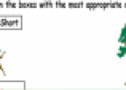
Comparisons: short and long
Tiching explorer Organización
- 2 lo usan
- 1855 visitas
Printable worksheet (PDF file) designed to develop the skills to establish differences between objects based on their height.
-

Game: Pig toss
Tiching explorer Organización
- 1 lo usan
- 2718 visitas
In this game we have to calculate the distance and height so as to help pigs to jump over the canyon safely.
-
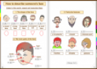
Interactive Book: Physical descriptions
Tiching explorer Organización
- 7 lo usan
- 2778 visitas
The resource consists of an interactive book about describing people. We learn to describe someone's face and hair. We talk about height and figure. We practice vocabulary related to the parts of the…
-
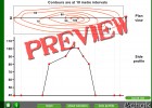
Contours
Tiching explorer Organización
- 2329 visitas
This is and interactive application to understand the correlation between contours on a map and the side profile of a geological feature. Students have to drag the dots on the X-axis to display the…
-
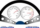
Reading scales
Tiching explorer Organización
- 2246 visitas
This activity is meant to be used on the interactive whiteboard to practice measurement scales of weight, speed, pressure, height, volume, temperature, etc... We can generate examples on the line or…
-
Unit 5: Weather and climate
EduBook Organización
- 2373 visitas
Altitude (n): the height of land measured from sea level. atmosphere (n): a gaseous layer that surrounds the Earth. climate (n): the atmospheric conditions that exist in a region over a long period of…
-

Video: World's Tallest Man
Esl video Organización
- 1 lo usan
- 2375 visitas
This report from CNN shows what life is like for the tallest man in the world. His extraordinary height was caused by a tumor and now normal clothes never fit him, they have to be custom-made. He has…
-

Complete. Contour lines
EduBook Organización
- 1616 visitas
Complete the following text with the words below. You can use the words more than once: steep – contour – close – far The elevation of the land is represented on maps by lines that connect points…


Te estamos redirigiendo a la ficha del libro...
